
Eighteenth and nineteenth century maps in the collection help to illustrate the development of the roads and town of Castleisland and district during the period 1729 to 1822.1
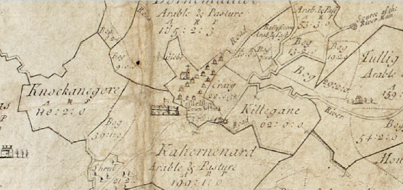
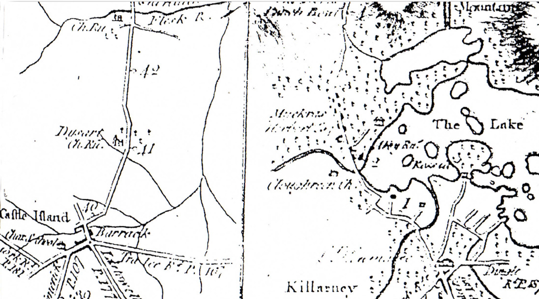
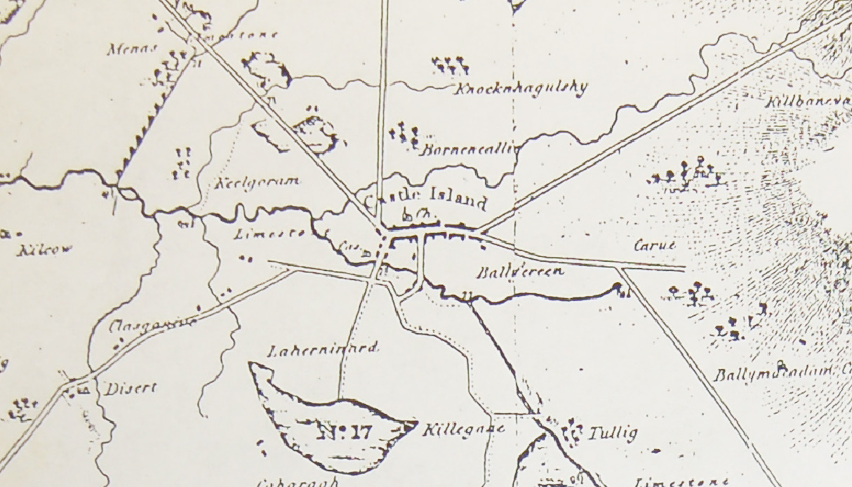
The maps were drawn by Hogan in 17292, George Taylor and Andrew Skinner in 17773 Alexander Nimmo in 18124 and by ‘unknown’ in 1822.5
Following on from this, a ‘Map of the New Roads through the Mountains between Castleisland in the county of Kerry and Roskeen Bridge’ was published in 1834 at which time the district was described as ‘almost inaccessible … where no species of improvement had ever been attempted’.6
The collection also contains references to late nineteenth century public works (Presentment Sessions) in the Castleisland district. The works took the form of new lines of road, road repairs, road widening (and general road maintenance), flagging, building of gullys, footways and fencing.
The works shed light on past associations, for example flagging was carried out in Castleisland in 1880 ‘between Dr Harrold’s gateway and the cross of the new Limerick line and between Maurice O’C Roche’s house and the Crown Hotel’. In 1887, works were conducted ‘in front of John Griffin’s public house and John M’Sweeny’s new house’.
Bridge building and repairs are also recorded, the importance of such works illustrated in a near drowning in 1901:
About three o’clock yesterday three men, a horse and a side-car were swept by the current into a deep hole while crossing the river Flesk near Castleisland on their way to the Kilsarcon graveyard … Mr Perry of Cork and others were carried into deep water a few years ago in this spot. About 25 persons were drowned in this passage across the river in the memory of the inhabitants of this district.
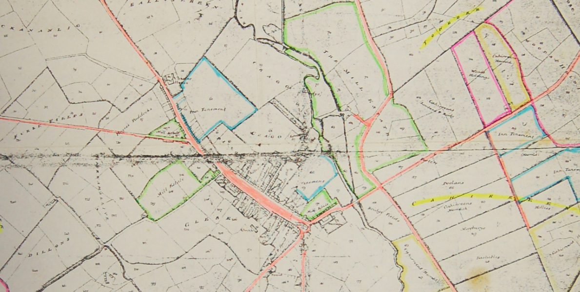
In this vicinity Twiss Bridge was built, which traverses the Brown Flesk River near Gortacappul.7 It is thought that at one time a toll was charged to cross it. It was built with a new line of road during the second half of the nineteenth century.8
In the same area Rice Bridge at Knockrower West, constructed in 1836 (Richard Griffith engineer) and known as Adraval bridge, was also associated with the Twiss family.9
Contemporary material in the collection includes a four page brochure, N21 Castleisland Bypass Road Improvement Scheme, Constraints Study, October 2001.10
_____________________________
1 Sir Herbert George Fordham's (incomplete) catalogue The Road-Books and Itineraries of Ireland 1647 to 1850 (1923) revealed how the first Irish road books, published in London in the years 1647-1655, were no more than lists of towns and guides.
2 IE MOD/49/49.1. Full title of Hogan’s map: A MAP of the SEIGNORY of CASTLE ISLAND, MANOR OF MOUNT EAGLE LOYAL, in the County of KERRY IRELAND The Estate of the Honourable Henry Art. Herbert Esqr of Oakley Park IN ENGLAND Survey'd Anno 1729 by Gart [?] Hogan (a copy of this map is held in IE MOD/A6).
3 IE MOD/52 comprises notes on the publication, Taylor and Skinner’s Maps of the Roads of Ireland Surveyed 1777 (1778) by George Taylor and Andrew Skinner, dedicated to the Right Honourable Edmond Sexten Pery, Speaker of the House of Commons. The book was revised in 1782 and issued with a supplement, The Post-Chaise Companion; or, Travellers' Directory through Ireland by publisher, book-seller and Irish State Lottery agent, William Wilson of 6 Dame Street, Dublin. An advertisement explained that the Post-Chaise was 'compiled from the only authentic Survey ever made of the roads in Ireland by Messrs Taylor and Skinner'. Scotsmen Taylor and Skinner’s work is generally held as the first road map of Ireland. The maps illustrate turnpikes and the main seats of landed residences. Subscribers to the book in Kerry included Rowland Bateman Esq, Christ. Julian Esq, Edward Leslie Esq, Samuel Morry Esq, Thomas Mullans Esq, Wm Meade Esq, Den Mahony Esq, Richard Orpen Esq, Wm Raymond Esq, James Supple Esq, Wm Sealy Esq, Wm Sandes Esq, Richard Yielding Esq and members of the Blennerhasset, Crosbie, Chute, Denny, Day Fitzgerald, Godfrey, Gunn, Hickson and Herbert families. In light of Taylor and Skinner's remarkable contribution to road mapping, it is surprising that so little is known about them.
4 IE MOD/49/49.3. Alexander Nimmo was employed by the Bogs Commissioners as part of the enquiry into the practicality of draining and cultivating bogs.  Collection holds a number of copies of Nimmo’s 1812 map of the Castleisland district. IE MOD/49/49.3/49.3.4 contains Michael O'Donohoe's observations on the map including the roads to Killarney, Tralee, Listowel and Limerick.  He remarked that the stone houses in Castleisland 'including where Dave Geaney now does business' were all built at this time'.
5 IE MOD-49-49.4-49.4.1.  Map is entitled 'Plan of the Town and Undivided Lands of Castle Island County Kerry Part of the Seignory of Castle Island and Manor of Mount Eagle Loyal 1822'. Michael O'Donohoe commented on this as follows: 'On 17 June 1824. An act for dividing, allotting and inclosing certain lands and waste grounds, called the town and undivided lands in the county of Kerry.  Daniel O’Connell was consulted by Lord Headley in Tralee regarding the above.  Map almost certainly done for the purpose of the division'. Document IE MOD/49/49.4/49.4.6, 'Roads in 1822' remarks on the Cork, Limerick, Listowel, Tralee, Killarney and Scartaglin roads.  It is transcribed thus: Cork: Via Cordal and Knocknaboul.  This road is often referred to as the Military Road as it was built by Elizabethan soldiers.  It was also known as the Butter Road.  It did not go through Ballydesmond, why not? Limerick: Via the present College Road and Glounsharoon Listowel: Via Pound Lane Tralee: Via Tralee Road, the old road was almost certainly also in existence at that time Killarney: Via Barrack Lane, Currow and the Mountain Road.  This is clearly shown on a Taylor & Skinner map of 1783.  T M Donovan in his Popular History of East Kerry tells us that, up to 1831, Barrack Lane Bridge was the only bridge across the Maine (pp142, 187) Scartaglin: Via Barrack Lane.  Nimmo’s map of 1812 gives the route as through Killegane, Coolavanny, Bawnaskehy and Coolnageragh.  This is confirmed by T M Donovan (p187).  The Firie, -Breahig Road connection was made in 1880-81.
6 Map drawing attributed to J Bastre. A report of the time by James Weale Esq stated 'It is remarkable that the only passes ever made through the district were effected at the instance and expense of the British Government immediately subsequent to the rebellion of the Earl of Desmond ... the people are turbulent, and their abodes being nearly inaccessible for want of roads, their wickedness has frequently escaped punishment ... new houses of a better class have been built or are building in great numbers in the vicinity of the new roads and also in the village of Newmarket, Castle Island and Abbeyfeale ... I am of opinion that the proposed road should commence at Castle Island and proceed eastward through the mountains ... if completed it would open a direct communication from Tralee and Castle Island to the city of Cork ... At present, from want of roads, no limestone can be drawn into the country and consequently the land remains untilled and the inhabitants are wretched ... when the new line of communication between Castleisland and the nearest towns in the county of Cork shall be completed, the traffic along this road will soon become of considerable importance' (see Weale's reports in Tralee Mercury, 30 August, 3, 6 and 10 September 1834). In 1837, it was recorded that 'a wild sterile bog and moor is becoming every day more fertile and valuable'.  See Morning Post, 4 September 1837, 'Crown Lands Ireland: 'relative to crown land experimental improvements at King William's Town, Cork and Cork and Kerry New Roads'.
7 Gortacappul, along with a considerable amount of land in Trughanacmy, was sold under the Land Purchase Act in 1901 by landlord Henry Arthur Edward Keane Herbert, Justice of the Peace and grandson of Henry Arthur Herbert of Muckross (Estate of Henry Arthur Edward Keane Herbert and James Hope Archibald Robert Craufurd Pitman and Spencer Campbell Thompson).  Lands included Carrigeenwood, Gneeves, Knockafreaghaun, Knockeencreen, Knockognoe, Knoppoge, Meenyvoughaun, Tooreennablauha, Bawnaskehy, Ballynahallia, Breahig, Caheragh, Castleview, Clashganniv, Coolavanny, Coolnageragh, Cliddaun, Fieries, Gortglass, Kealgorm, Tullig, Canguilla, Glanlea, Cloonacurrig, Kilcow, Lisheenbaun, Knockyeala, Scartaglin, Foiladuane, Garries, Carrigeencullia, Rosscroonaloe, Crohane, Derrybanane, Lahard, Cloondonigan Upper and Lower. Herbert, who in the late nineteenth century built a residence of wooden construct on Dinish Island in the Kenmare river, was lauded at the time for giving the area much needed employment and described as 'extremely popular in the locality'.  His actions following a boating accident on the Kenmare river in 1908 recommended him to the Royal Humane Society.  He died at Mentone, Monte Carlo in January 1931.
8 Its name suggests an association with the Twiss family: nearby Haremount House and Rockbrook House were Twiss residences. Miss Frances Twiss died at Rockbrook House in March 1865 aged 72.  In December of the same year, Miss Frances Twiss, eldest daughter of Francis Twiss Esq of Rockbrook House, died suddenly at the home of her sister in High Street, Tralee.
9 Twiss and Fitzgerald of Adraval intermarried. Note on the Twiss family of Haremount and Fitzgerald of Adraval in Philip of the Hundred Cows (2015).  See the collection for notes on associations between the family of Twiss and the families of Myles and Saunders of Carker House, Scartaglen (and for later associations with this property in the Casey and O'Donoghue families).
10 IE MOD/66/66.2.  Other items in the collection with roads related material include IE MOD/11, IE MOD/49, IE MOD/52, IE MOD/65.