

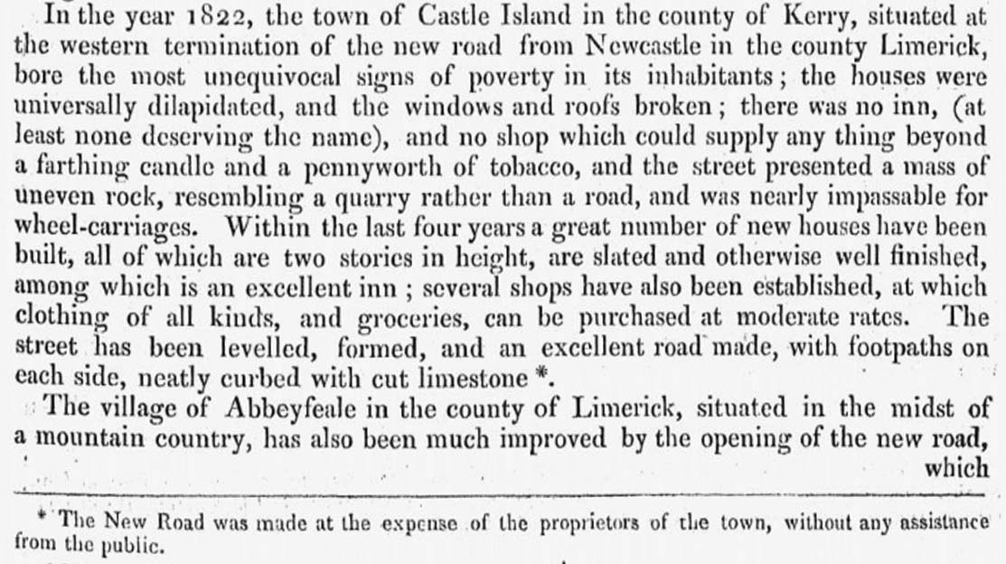
In the year 1822, the town of Castle Island, in the county of Kerry ... bore the most unequivocal signs of poverty in its inhabitants ... the street presented a mass of uneven rock, resembling a quarry rather than a road
 – Richard Griffith, Civil Engineer1
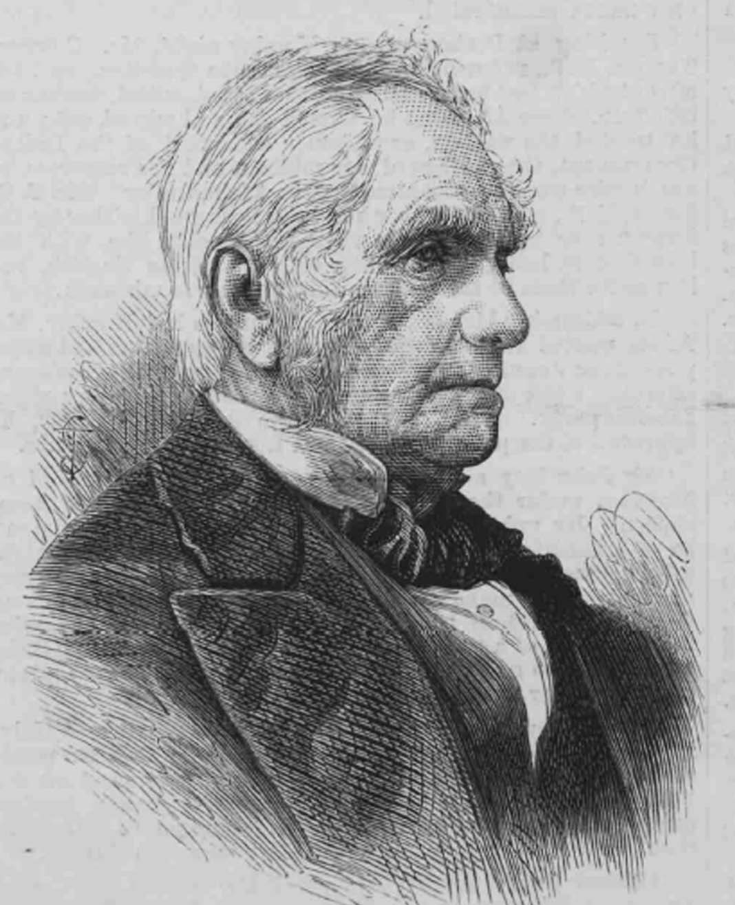
It is clear from material in the collection that Michael O’Donohoe had a great appreciation for the work of nineteenth century civil engineer, Sir Richard Griffith.
Michael consulted Griffith’s reports, maps and valuation records to help depict the changing face of Castleisland.
Naturally, he also put a face on Griffith:
Sir Richard John Griffith 1784-1878, Irish geologist and civil engineer, born in Dublin. He became an army officer in the Royal Irish Artillery in 1799 (15 yrs?) but later studied engineering in London and Edinburgh. Returned to Ireland 1808 and surveyed the coalfields of Leinster and examined the Irish bogs for a government commission. As Commissioner of Valuations after the Irish Valuation Act of 1827 he created Griffith’s Valuations for country rate assessments. He published his Geological Map of Ireland in 1855 and was consulted in all major Irish building projects including the National Gallery and the Museum of Natural History.2
A short essay on the development of roads in Kerry (IE MOD 65/65.1/65.1.1) traces Richard Griffith’s first visit to Tarbert and Tralee and the subsequent construction of roads and bridges including Headley’s Bridge and Feales Bridge (Wellesley Bridge).
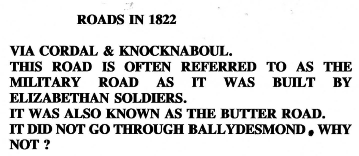
Another document, ‘Roads in 1822’ (ie-mod-65-65-2-65-2-1) contains notes on the main roads entering the Castleisland district and their direction, including Limerick, Listowel, Tralee, Killarney and Scartaglen. A note on Killarney Road includes a remark on Barrack Lane Bridge.
Other material includes Valuation Office Ireland maps of the town of Castleisland. Noteworthy is the town of Castleisland illustrated in lots (ie-mod-32-32-1-32-1-4), one of which included Rack Lane near the old court house, which may take its history from the 1798 period.
Michael made ample use of Griffith’s Valuation records to create detailed records of the parishes of Ballincushlane, Ballymacelligott, Brosna, Castleisland, Currans, Dysert, Kilcummin, Killeentierna, Molahiffe, Nohoval and O’Brennan.
Michael also observed how Griffith’s Valuation (the valuation fixed by government for rating purposes in 1853) was later taken up as a political tool by the Land League as the proper standard of rent.3
That’s the word to say
Down with confiscation
Not a cent we’ll pay
But John Roche’s Valuation.4
Parish Records of the Castleisland District
A selection of Michael’s parish records can be viewed below.
Page 1 (of 4) ‘Richard Griffith’s Valuation of the Civil Parishes of Castleisland, Ballincushlane, Killeentierna and Dysert 1 March 1853’. The parishes are colour coded; the bottom of the document contains verse: ‘That’s the word to say/Down with confiscation/Not a cent we’ll pay/But John Roche’s valuation’
Page 2 (of 4) ‘Griffith’s Valuation 1 March 1853’ contains details of schools and buildings used by the clergy in the parishes named in IE MOD/33/33.1, including a Wesleyan Chapel at Cloghermore, townlands in which they were situate, notes on occupants and other notes, for example, Scartaglin school 1861, new school 1981
Page 3 (of 4) contains notes on pounds, mills, forges, and other buildings extracted from the valuation including occupants plus explanatory notes; for example, John Healy had a tuck mill at Knocknaboul, ‘Tucking or fulling was the art of scouring and beating woollens as a means of thickening’
Page 4 (of 4) ‘Valuations March 1 1853’ contains notes on schools, pounds, graveyards, churches and yards and mills in townlands of Castleisland parish
‘Parish of Ballincushlane’ contains an alphabetical list of townlands in the parish (Adraval to Tooreenascarty)
‘Parish of Ballincushlane’ (Bateman to Wyse) with associated townlands
‘Ballymacelligott 65 Townlands’, Ahane to Tursillagh
‘Ballymacelligott’, Blennerhasset to Ventry, with associated townlands
‘Brosna Townlands’, Ahaun to Tooreennablauha; Bateman to Thompson
‘Castleisland’, Ahane to Tullig
‘Figures 1853 rounded up’ contains list of landlords numbered 1-9, Drummond to Crumpe, five unnumbered landlords (Stokes, Raymond, Twiss, Coltsman, Blennerhasset) and size of their holdings, Drummond holding the greatest, 12.250 and Blennerhasset holding the least, 1,447
‘Currans’, Ardcrone to Urrohogal
‘Dysert’, Ballahantouragh to Parknasmuttaun; includes Maunsell to Twiss, with associated townlands
‘Killeentierna’, Annabeg to Toornanoulaghal
‘Killeentierna’, Andrews to Twiss, with associated townlands
‘Parish of Molahiffe’, Ballinvarrig to Skahies
‘Nohaval’, Ballinvariscal to Scart
‘O’Brennan’, Ballincallig to Tylaghwith
________________________
1 Report on the Roads made at the Public Expense in the Southern District in Ireland (1831) by Richard Griffith, Civil Engineer.  Extract in full: 'In the year 1822, the town of Castle Island, in the county of Kerry, situated at the western termination of the new road from Newcastle, in the county of Limerick, bore the most unequivocal signs of poverty in its inhabitants; the houses were universally dilapidated, and the windows and roofs broken; there was no inn (at least, none deserving the name) and no shop which could supply anything beyond a farthing candle and a penny worth of tobacco; and the street presented a mass of uneven rock,  resembling a quarry rather than a road, and was nearly impassable for wheel-carriages.  Within the last four years a great number of new houses have been built, all of which are two stories in height, are slated, and otherwise well finished – among which is an excellent inn; several shops have also been established, at which clothing of all kinds and groceries can be purchased at moderate rates.  The street has been levelled, formed and an excellent road made, with footpaths on each side, neatly curbed with cut limestone'.  An earlier notice advised that 'on the completion of the road from Limerick to Castle Island, Mr Bourne will establish a mail-coach from Limerick to Killarney which will convey the Dublin mails to Killarney at least twelve hours sooner than the present route' (Freeman's Journal, 9 January 1829).
2  Michael consulted Chambers' Biographical Dictionary for biography.  Griffith's baronetage passed to his son, Sir George Richard Waldie-Griffith (1820-1889) who married Eliza, youngest daughter of Nicholas Philpot Leader, MP, of Dromagh Castle, Co Cork and had issue two daughters, Maria, who married Thomas Taylor of Chipchase Castle and Isabel, who married Mr Turner-Farley of Wartnaby Hall and a son, Sir Richard John Waldie-Griffith, 3rd baronet. Thrice married Sir Richard died in a London nursing home in July 1933.  He had no children and the heir to the title in 1933 was Colonel T[homas] G[eorge]Taylor, his nephew.  'Richard Griffith and the Roads of Kerry' by Seán Ó Lúing, a two part article on the work of Richard Griffith, was published in the Journal of the Kerry Archaeological and Historical Society in 1975 and 1976.  Michael O'Donohoe identified items of Castleisland interest contained therein.  See ie-mod-65-65-3-65-3-1, ie-mod-65-65-3-65-3-2, ie-mod-65-65-3-65-3-3.
3 The Irish Revolution (1912, p115) by Michael John Fitzgerald McCarthy: 'Griffith's Valuation, that is, the valuation fixed by the Government for rating purposes, was now adopted by the Land League as the proper standard of rent, and tenants asked for reductions bringing their rents down to that figure. Mr T. D. Sullivan, one of the new Parnellite members, was then writing a series of verses called 'Land League Lays' in The Nation which the people were singing everywhere to old Irish airs. The chorus of one of these, called 'Griffith's Valuation', ran: That's the word to say,/Down with confiscation,/Not a cent we'll pay/But Griffith's Valuation'.  Sullivan's four-stanza poem, 'Griffiths' Valuation', No IV of his 'Lays of the Land League', was published in The Nation on 20 November 1880.  The first stanza runs: Farmers, far and near,/Long despoiled by plunder,/Let your tyrants hear/Your voices loud as thunder;/Shout from shore to shore/Your firm determination/To pay in rents no more/Than "Griffith's Valuation."/That's the word to say,/To end their confiscation;/That's the rent to pay –/"Griffiths' Valuation."
4 This was evidently a play on a verse current at the time, quoted in Gallowglass or Life in the Land of the Priests (1904) by Michael John Fitzgerald McCarthy (p401): Standing firm and strong,/In dauntless combination,/We'll have our lands ere long/At the poor law valuation!/That's the word to say,/Down with confiscation,/Not a cent we'll pay/But Griffith's valuation.